
A History of Preston in Hertfordshire
A Roman road through Preston ?
There is little information about Dinsley, Preston and their environs before the Domesday Survey of 1086 - however, an article
by RT Andrews in the East Herts Archaeological Society Transactions Vol 3 Part 1 (1905 ) postulates that there was a Roman
road that traversed Preston.
Roman Remains in Welwyn and Neighbourhood states that it had been well-known for a long time that Welwyn and its
surrounding area had been occupied by the Romans - the proof being the continual discovery of Roman coins, burial urns and
buildings in the area. The Hertfordshire Mercury of March 1904 included this comment from a correspondent:
The article continued, ‘It is believed that another of these Romanised British ways commenced on the line of
Ermine Street, near Ware…ran on to Hertford….then it went along the North Road to just beyond the
Hertford General Infirmary…From this spot such a way as this can be traced almost continuously by roads
and footpaths (for many of the footpaths are often much older than the contiguous roads) onward for several
miles….(through) Tewin…the south side of Knebworth Park and by Graffridge Wood, then on to St Pauls
Walden Church, Hitch Wood and the south-west side of Temple Dinsley, and so by Hunsden House (aka
Castle Farm) and Offley Holes to a point two miles west of Hitchin; here it crossed the Icknield Way half a
mile east of Highdown and so on to the west of Pirton Church to Apsley End…’
It was also reported that, ‘from Potters Heath there runs a direct pathway to Codicote Heath (which is said to have been a
Roman camp). From the Heath there is a an old lane running westward to Kimpton Mill….and so by an easy journey to Luton,
by Peters Green…partly by road and partly by footpath.’
Interestingly, (in view of Preston’s location and topography, comments about which have been made previously) the article
continued, ‘Thus it will be perceived that although the Romans had no way in this district of their own providing, yet there was
an open British track of sufficient dimensions to suit their purposes; it also ran along fairly high and dry ground and not too far
from the water, which was a matter they were always careful to secure’.
Tales of Roman roads
Most will have heard tales of Roman roads - of how they ran straight as
an arrow for miles, and how there is a Roman road at such-and-such a
place. But these commonly-held beliefs should be examined.
Near my wife’s childhood home at Pontypool, there is a way that locals
call “The Roman Road”. It drops from a height of around 1,000 feet to
the Monmouthshire and Brecon Canal. Even today there are clearly-
visible large and rounded stones that formed its surface (its ‘metalling’,
which has always struck me as a curious term) and the occasional curb
which is treacherous for the walker - in fact, the whole way is
treacherous in a wet day, of which there are many at Pontypool.
The proximity of this ‘Via’ to Caerleon and its extensive Roman fortress
adds to the possibility of ‘our’ road being indeed Roman.
Re: Roman roads or viae
Moreover, in 2004 there was an assessment of “Roman roads in South Wales” by the Glamorgan-Gwent Archaeological Trust.
It endorsed several routes as being Roman roads, but Appendix 1 listed Roads in OS files for which there is insufficient
evidence to map and Appendix 2, PRNs for isolated sightings of possible Roman roads and rejected sites. There were sixteen
‘roads’ in these appendices. They had comments such as ‘Neither has any certain evidence and the alignments are not
particularly compelling’; ‘exhibiting no signs of Roman origin and more likely to be medieval’ and ‘others appear to be entirely
conjectural’.
So, the assertion in 1904 that there was a Roman road that passed through Preston might be viewed with some scepticism -
especially as I have found no other reference to its existence.
An additional point that stands out from the maps of confirmed Roman roads in South Wales is that many were hardly
‘straight’ - which will come as no surprise to those familiar with the topography of the area.
However, in around the year 2000 a survey of the road was arranged
by a local community council. Its conclusion to the disappointment of
many was that the road was too modern to be Roman. Yet it is still
called “The Roman Road”.
The “Roman road” near
Pontypool
When the Romans first invaded England, they had no choice but to advance using the existing trackways - to build their own
viae would simply have taken too long. Surviving accounts show that detachments were sent ahead to clear the way (in their
words, ‘opening up’ - aperire) for the body of troops and their baggage train, not constructing but improving what they found.
There are many famous Roman roads - the ‘great roads’ as they were called in the earlier article. They were super-highways
used for conquest, communication and consolidation, a means to move armies and their war machines around as quickly as
possible. They were an integral part of Roman logistical solutions. Portions of these ran straight for miles.
Then there were the networks of minor, secondary roads that the Romans used. These were not built by the invaders, but were
ancient local/native roads and footpaths which they commandeered and which were often never metalled. These would hardly
have appeared as a straight line either on maps or on the ground. A Secret History of the Roman Roads of Britain states that
‘Existing winding trackways were sometimes utilized by the Romans….This is noticeable especially in Hertfordshire”.
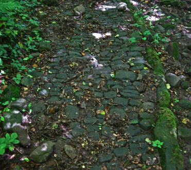
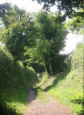
Below is a photograph of such a Hertfordshire minor Roman road as it appeared almost two millennia after it had been
adopted:
The ‘great’ Roman roads of Hertfordshire
Three of the great Roman roads ran through Hertfordshire - Watling Street, Ermine Street and the Icknield Way. In addition,
other roads centred on St Albans (Verulamium)
Watling Street
This most important road ran roughly north-west from the Kentish ports including Dover to Wroxeter in Shropshire via
Rochester, London, Brockley Hill (near Stanmore, North London) then NNW to St Albans and Dunstable.
Ermine Street
This via was the second most important Roman road and was laid approximately due north and directly connected London and
Lincoln. It’s route is largely duplicated by the A10 to Royston, Herts where it crosses the Icknield Way. Thus, it was nearer Ware
than Hertford and ran north through Hertford Heath, Thundridge and Buntingford, (the latter being around eleven miles due
east of Hitchin) and thence Braughing (where there was a Roman settlement making this an important junction).
Ware was a hub of roads, with one running from St Albans and another to Baldock where another road linked with St Albans.
Icknield Way
The Icknield Way may well be the oldest road in Britain, extending from the Dorset coast to Norfolk. It was thought to have
predated the Roman occupation, although recently this has been questioned. From Toddington to the north of Dunstable it ran
about five miles north of Luton and three miles north of Hitchin (near Ickleford), continuing on to Royston.
Other Roman roads in Hertfordshire
One led north-east from St Albans near Sandridge, Coleman Green and Waterend towards Welwyn and then on to the
settlement at Braughing. It joined Ermine Street at Colliers End.
Another road ran from London via Hatfield to Stevenage, Herts. Traces of this road have been seen at Alexandra Palace,
Muswell Hill, Brookmans Park, Hatfield Park, Welwyn Garden City to Digswell water and then Woolmer Green, Knebworth and
Stevenage - where it met a road that ran from Baldock to Coleman Green (for St Albans). This latter route at Braughing had a
junction with the next road to be mentioned and passed Lammas Wood, Ayot St Lawrence, crossing the River Mimram by
Kimpton Mill, and thence to the Codicote-Wheathampstead road and Coleman Green.
A secondary road went from Braughing to Baldock and Godmanchester. At Baldock, it joined roads from St Albans and Welwyn
and crossed the Ichnield Way.
The discovery of Roman roads in Britain is an on-going process. A definitive assessment was Roman Roads in Britain (1903)
by Thomas Codrington. This was superseded by ID Margary’s exhaustive 546-page tome with the same title, the 1967 edition of
which is referred to here. I note that Margary’s footnotes include copious references to volumes five and thirteen of the East
Herts Archaeological Society Transactions - but not the article in volume three which is quoted at the start of this article.
Between 1955 and 1967, a detailed exploration of Roman roads in the south-east Midlands by a group called Viatores revealed
many new examples of minor Roman roads around Bedford, Bletchley and St Albans. More additions to the catalogue of known
Roman roads have been made since 1967. Significantly, in view of the subject we are discussing, Margery wrote:
‘The inclusion of minor roads is always a difficult problem that can often be solved only by
consideration of evidence of alignment, relation to Roman occupied sites and constructional
details’
To illustrate the progress of research in this field, the Kimpton (six miles south of
Preston) History Group commented that “in the last ten years archaeologists have
discovered a network of minor Roman roads, built for civil rather than military purposes.
These roads often followed pre-Roman tracks….Three such routes passed through
Kimpton:
ST. ALBANS - ICKLEFORD near HITCHIN, via edge of Gustard Wood Common -
Kimpton Hall Farm - Kimpton Memorial Hall - Cuckolds Cross.
COLEMAN GREEN (Near SANDRIDGE) - BALDOCK, via rear of Ayot St. Lawrence
Church - spine of hill down to Kimpton Mill (called Laver Street)
AYOTBURY (Near WELWYN) - FRIARS WASH, via the high ground to the north of the
Lea Valley, passing behind Cross Keys Public House - then changing direction slightly to
follow the now disused road which ran up to 1874 from Blackmore End to Raisins Farm.”
This report is dated 1999 and appears to divide the one road mentioned below into three
roads.
(The details that follow have been mostly extracted from ID Margary’s Roman Roads in
Britain [1967 edition] )
Hall Lane, leading up from
Kimpton to Hall Farm
So, did a minor Roman road traverse Preston?

After a lengthy preamble, we return to the nub of this article, did a Roman road pass through what became Preston?
The argument against:
1) I have found only one reference to this road - in the East Herts Archaeological Society Transactions of 1905 - as detailed in the
opening paragraphs above.
2) In The History of Tewin (2009), there is no mention of a Roman road (and no other evidence of Roman occupation of the
village) in the vicinity of Tewin as stated by RT Andrews. I feel sure that if there was the merest suggestion of a road passing
through Tewin, it would have been grasped with eagerness by its historians.
3) Few, if any, Roman finds have been made in Preston, to my knowledge
The argument for:
1) ID Margary’s Roman Roads in Britain makes several references to articles in volumes of the East Herts Archaeological Society
Transactions. It is inconsistent to do this and not reference RT Andrews’ piece which was also in their work - even if it may not
have been found by Margary as it was not obvious by its title that the paper mentioned Roman roads.
2) RT Andrews (1838 - 1928) was an antiquarian, architect, surveyor and author of a bibliography of Ware, who founded the
East Herts Archaeological Society and, with his brother, also founded Hertford Museum of which he was a curator - so, some
impressive credentials!
3) Andrews’ piece mentions a Roman road at Kimpton Mill - the existence of which is accepted - this adds credence to his other
comments.
4) If this Roman road existed, it should not be a surprise because there is no doubt that another Roman road passed near
Preston following some of path of the St Albans Highway, to the south of the village.
Roman Roads in the South East Midlands by Viatores (1964) traces its path: “…At the southern boundary hedge of the grounds
of Stagenhoe, a field-gate is on the line and inside the gate to the north, a low agger (a Roman-built embankment or elevation
that provided a draining base to the road) is visible for twenty-five yards the the point where the present lane, which marks the
course of the eighteenth century St Albans to Hitchin road, swings off in a wide curve to the west, first a track and then as a
hollow way.
The line of the Roman road goes straight on ……until the eighteenth century road joins it from the east. From this junction for a
quarter of a mile to the north edge of the wood, the eighteenth century road, now a wide hollow way, marks the course as far as
the modern St Pauls Walden to Preston road on the hill by Hitchwood Cottages. Northward, up the hill from the cottages, the
agger twelve feet wide is to be seen for 100 yards on the west side of the modern road. At the gate lodge of Temple Dinsley the
modern road following the line of the eighteenth century St Albans Highway, which name is still in use locally, diverges eastward
in a deep cutting, but the Roman road goes on due northward, following the natural shoulder of the (land).”
So, there was certainly known Roman activity and transportation very close to Preston and another via close-by would not be a
leap of faith.

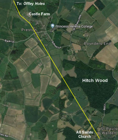
My comments: Hitch Wood would have been far more extensive in Roman times - and even today there are a number of
paths criss-crossing the forest. No mention is made of how close to Temple Dinsley the road ran; just that the road was to
the south-west of Temple Dinsley.
The most obvious route of the road would be, after cutting through Hitch Wood, to follow Preston Hill Farm Road, Back
Lane, Butchers Lane and then the Charlton Road to Offley Holes. But this is pure conjecture.
(1) Alignment

Let us use the Margary’s yardstick of how to identify Roman roads: “…consideration of evidence of (1) alignment (and)
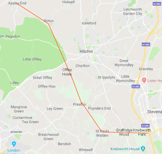
(2) relation to Roman occupied sites”. This was what Andrews wrote: ‘…another of these Romanised British ways
commenced on the line of Ermine Street, near Ware…ran on to Hertford….then it went along the North Road to just beyond the
Hertford General Infirmary…From this spot such a way as this can be traced almost continuously by roads and footpaths (for
many of the footpaths are often much older than the contiguous roads) onward for several miles….(through) Tewin…the south
side of Knebworth Park and by Graffridge Wood, then on to St Pauls Walden Church, Hitch Wood and the south-west side of
Temple Dinsley, and so by Hunsden House (aka Castle Farm) and Offley Holes to a point two miles west of Hitchin; here it
crossed the Icknield Way half a mile east of Highdown and so on to the west of Pirton Church to Apsley End…’ The approximate
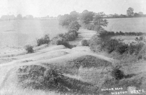
route from Knebworth Park is shown below:
If there was a Roman road through Preston,
what course might it have followed?
…..(2) relation to Roman occupied sites:
Apsley End is a close neighbour of the Bedfordshire village of Shillington - which was created from a number of villages whose
names ended in ‘End’. The following is an abbrieviated version of comments made about the history of Shillington, “The
Bedfordshire Historic Environment Record [HER] contains information on the county's historic buildings and landscapes and
summaries of each entry can now be found online as part of the Heritage Gateway website. There is quite considerable evidence
for Romano-British activity in the modern parish of Shillington.
The Viatores are a group who are dedicated to trying to discover Roman roads in the modern landscape. There is a possible
Roman road in Shillington [HER 10472], evidence having been found outside 52 High Road. This consisted of an old road
surface four inches below current by builders in June 1959. The orientation seems to have been north-south or, perhaps, north-
west to south-east. The surface included metalling with pebbles on the grey clay subsoil. The road was certainly in use in the
late Middle Aged as sides of a 15th century leather shoe were found.
A Roman villa was found in 2007 to the north-east of Upton End at Ashton Well [HER 15256].
Considerable numbers of Roman coins have been found in the parish. An antoninianus of Claudius II Gothicus (268-270) was
found in a ploughed field [HER 9425]. Seventeen bronze coins from the 3rd to 5th centuries (260-410) were found in
September 2005 near Chibley Farm, along with a Roman bracelet, finger ring and brooch dating from the 1st century AD. A
single coin from the reign of Nero [54-68] dating from the period 55 to 60 AD was also found. Three more Roman coins were
found south-west of Windmill Farm in 2004 [HER 18375]. One was dated to the reign of Claudius Gothicus or early in the reign
of Aurelian [268-270], one was definitely Aurelianic (270-275) whilst the other was dated to late in the reign of Constantine the
Great (306-337), specifically 329 to 336.
More coins were found at Northley Farm between 2005 and 2006 [MER 18388]. Many are badly corroded but seem to range
between 1st and 3rd centuries in date, others can be more precisely dated to the reign of Hadrian (117-138), Antoninus Pius
(138-161), Septimius Severus (193-211), the British usurper Allectus (293-296) and Constantius II (337-361). A coin of
Antoninus Pius dating to 145 or 146 was found south-east of Northley Farm in 2006 [HER 18394] along with a coin of
Constantine dated 330 to 335. A bracelet and tweezers were also found.
A brooch of a type known as Colchester and dating from the 1st century AD was found south-west of Northley Farm in 2006
[HER 18400]. With is was a 3rd to 5th century finger ring and three coins dating from the reign of Vespasian (69-79), Trajan
(98-117) and from the 2nd century. A stud and a trumpet brooch were found north-east of Upton Farm between 2006 and 2007
along with 20 coins ranging in date from the 1st century to 409 [HER 18412]. Six coins were found west of Northley Farm in
2006 [HER 18421]. Two are corroded and may date from 1st to 3rd centuries. The others are clearer, two dating to the reign of
Vespasian, one to the reign of Nerva, specifically 97 and one to the reign of Antoninus Pius.
In 2007 jewellery and coins were found at Chibley Farm [HER 18482]. The jewellery comprised another Colchester brooch, a
brooch of a type known as Langton Down, three of a type known as Hod Hill (all first century in date) and two T-shaped
brooches which may be 1st or 2nd century. Twenty eight coins were also found dating from 260 to 402. Another Colchester
brooch was discovered north-east of Upton Farm in 2007 along with a pin and a spoon and 36 coins dating between 69 and
402.
One coin hoard found in Shillington is of international importance. In was found in 1997 south-west of Kettledean Farm and
comprises 123 gold aurei and 7 silver denarii. The aurei date from the reign of Tiberius (14-37 AD) to that of Vespasian and
mostly look as if they had been struck yesterday, so their circulation must have been minimal. Many of the coins are rare types
and one is unique. The silver coins range in date from the Republic to Vespasian suggesting that all the coins were deposited
either during the reign of that particular emperor or very shortly thereafter. The hoard was declared Treasure in 1998 and is
now in Stockwood Museum in Luton. The best guess is that the coins were deposited for ritual purposes as a ritual or cult site.
Three Roman brooches were found west of Northley Farm in 2006 [HER 18393], one of Colchester type, another a T-shaped
brooch. Two other finds come from a similar area – one of a 3rd to 5th century plate brooch [HER 18495] the other a 1st o 2nd
century brooch in the shape of a swan [HER 18496]. A cosmetic mortar was found west of Northley Farm in 2005 , dating from
the 1st or 2nd century [HER 18498] and a small assemblage north-west of the farm was found in 208 [HER 18585]. This
comprises two 1st to 3rd century bracelets; two Colchester brooches; a 1st to 3rd century finger ring; a pin; two Hod Hill
brooches; a pair of tweezers and a corroded coin.
A Roman bracelet and pin were found east of Chibley Farm near the Stondon boundary in 2006 [HER 18399]. Nearby another
pin was found in 2008 [HER 18583].’
The amount of Roman material found in Shillington, particularly the huge number of coins, is very surprising
for an area which, before the late 20th century, had no obvious Roman associations such as a major road (like
Watling Street) or Roman town”. However, most if not all of these finds were made after Andrews’ comment in 1905.
In view of this, one might ask ‘Why did Andrews select Apsley End as the destination of this road’; ‘How and why did he decide
on the course of this road - which included Preston. Was it simply by following a (fairly) direct line of roads, lanes and footpaths
from maps.’ There is so much we do not know about the background to his claim and without this information, it is difficult to
make a judgement call on his view.
In December 2019, Keith Fitzpatrick-Matthews (Hitchin Museum Curator and Heritage Access Officer) kindly provided these
comments: “
Re: Roman roads “I’d be very wary of accepting Margary’s ‘minor roads’ in our part of the world and even more wary of R T
Andrews’ speculations (in his time, the criteria for establishing what was significant or not in the Roman period were much looser
than we would accept today).
Most of Margary’s local minor roads are based on the work of a group of the Viatores, who worked in the 1950s and early 1960s,
as you point out. They were very enthusiastic and published a book detailing a dense network of roads in the south-east Midlands.